Free license
Géoportail
Géoportail is a service provided by the French government which allows you to consult various types of cartographic data on our country. Accessible free of charge, it is a real mine of information.
- 18/11/2021
- 1175 All specs
Play Store
1 906
App Store
1
Download Free version- Online service All Internet browsers
- Android
- iOS iPhone / iPad
-
Why use Géoportail?
-
How to calculate the distance on a given area?
-
What are the new features of the latest version of Géoportail?
-
Which OS is Géoportail compatible with?
-
What are the best alternatives to Géoportail?
Description
Géoportail is a cartographic service that offers an immense knowledge and data base on French territory. Accessible free of charge, it allows all users, whether professional or not, to consult the available maps and create their own maps with the data of their choice.
Géoportail is an online service. To access it, you just need to use a computer (or possibly a mobile device) with an internet browser. Easy to use, it will allow you to find the information you need, or to carry out documentary research. You can also find the basic tools (called essential) on your mobile devices under iOS (iPhone, iPad) or Android.
The Géoportail cartographic site is made available free of charge by the IGN (the French National Institute of Geography).
Why use Géoportail?
Géoportail is an easy-to-use website that gives you free access to multiple data of all types on our country (geological, demographic, cadastral, town planning, etc.). This access to data falls within the framework of the European INSPIRE directive which aims to facilitate the dissemination of geographic information.
Very easy to use, the site is accessible to all users regardless of their computer or mapping level. It can therefore be suitable for beginners as well as professionals. In either case, the data may be of interest to users.
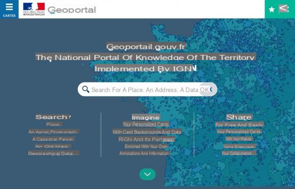
When you arrive on the site, you are offered three ways to use it. However, on arrival you will be able to carry out the same searches, only the start will be different. You can therefore: Search (carry out a search by place, cadastral number, etc.), Imagine (create maps with the data of your choice), Share (share the maps that you have created). You can create an account (free of charge) in order to save your searches and the maps you have created.
In any case, to start you will have to search for a place, in order to display the map of the area that interests you. By default, this is a simple map with streets, etc. You can zoom in and out relatively efficiently. The zoom level basically depends on the basemap you are using.
Because the particular point of Géoportail is that: being able to change the cartographic data on the screen. You can thus display a demographic map, the cadastral plan, the map of Natura 2000 zones, the map of agricultural areas, the location of schools and public services, etc.
To do this, all you have to do is use the left menu and browse through the various categories offered. When you click on a basemap, it is immediately added to the current view.
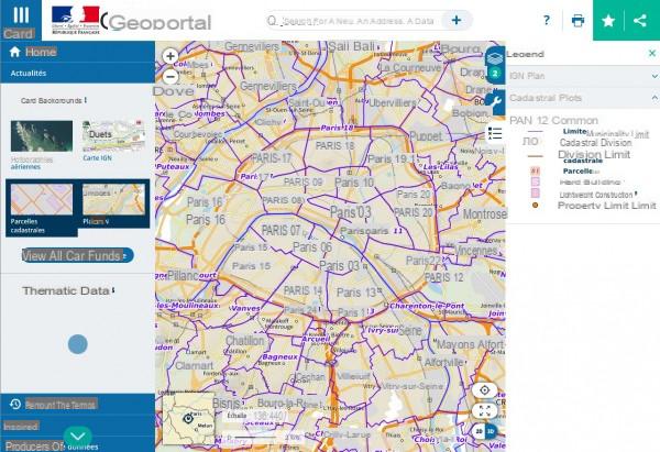
The small menu on the right allows you to manage the active base maps. You can delete them, deactivate them and even manage their opacity, this allows with certain backgrounds (the opacity is managed differently by the selected backgrounds) to superimpose the information on the map. Via this menu you can also display the base map legend (in the Legend menu, choose the base map that interests you).
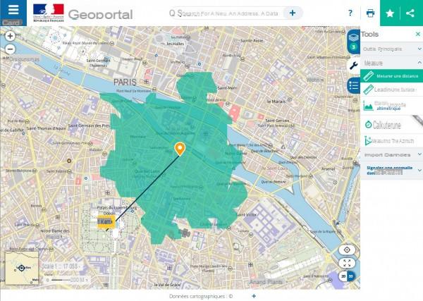
Always on the right, the Tools menu allows you to add annotations on your map (places for example), to calculate a route or to display coordinates according to the systems: geographic, Web Mercator, lambert 93, Lambert II extended and UTM 31N (our metropolitan country). You can also display (or not) the gridlines.
At any time, you can save the current card with all its funds to your account to come back to it later.
In the interesting or educational tools (depending on whether you are an individual or a professional) you will notice the presence of historical maps.
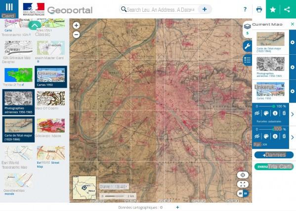
It is thus possible to display the area with a 1950 basemap, aerial photographs taken in the 1950s to 1965, a staff map created between 1820 and 1866, the Cassini map, and many more. others.
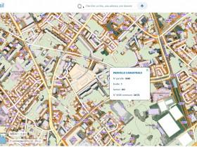
For professionals, academics and researchers, note that the classic IGN maps (scan of IGN maps), IGN topographic maps, IGN maps (digital IGN maps), relief map, geological maps, cadastral maps are also available. , etc. You also have additional tools: distance measurement, area measurement, altimetric profile, isochrone calculation, azimuth measurement.
Many areas of base maps are available: agriculture (soils, rivers, plot register, etc.), culture and heritage (preventive archeology, museums and monuments, etc.), economics and statistics (housing, demography, level of life, town planning, etc.), sustainable development and energy (risks, sea and coast, land use, protected areas, etc.), territory and transport (IGN, geodesy, geology, hydrography, cadastre, public facilities, etc. ), health and social, tourism and leisure (stopover villages, for example), education and research.
Note that Géoportail works with the Open Source mapping of OpenStreetMaps.
How to calculate the distance on a given area?
Go to the Géoportail online service. In the search bar, enter your address (or at least your municipality). The map of your address is displayed on the screen, you can zoom in to your address if you wish (if you have not entered your full address, for example).
In the menu on the right, go to the tools (adjustable wrench) and click on the drop-down menu titled Measures. From the list, choose Compute Isochronous. Enter your address as the starting point (at the top) or click on the staff to place the starting point by hand. Then click on the right icon (the one with the numbers) to switch to isodistance and enter the distance you want to appear.
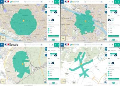
The result, contrary to what you might think, is not a round area. Indeed the application takes into account what is accessible on foot via streets and roads and what is not, so the area can sometimes have odd shapes, especially if you live in a village. The more you live in a dense area, the less quirky the area will be. If you live in the countryside, the area will be very strange, as it will only take into account the roads, without taking into account the footpaths.
The area calculator is still in beta. Note that it calculates the distance you will travel from your point of origin, not the radius. So if there is no direct street and you have to change direction several times, you will travel more distance.
If you want to know the distance as the crow flies between one point and another on the map, do not hesitate to use the Measure A Distance tool. Click on the first point then bring the mouse to the next point, the distance appears in real time next to the cursor.
What are the new features of the latest version of Géoportail?
To keep you informed of the latest data put in place on the Géoportail site, you can subscribe to the newsletter (by e-mail) directly from the site reception.
New data cards are added regularly. For example, as of October 29, 2021 you can view the aerial images of storm Alex.
Which OS is Géoportail compatible with?
Géoportail is compatible with all operating systems (Windows, Mac, Linux) and even with mobile systems (Android and iOS), preferably with a tablet, but also possible on a smartphone. Indeed, Géoportail is an online service, to open it you just need to use a web browser (internet connection required).
You can also find the essentials of Géoportail on your mobile devices under Android (from version 5.1) or iOS for iPhone or iPad (from iOS 11.0) also compatible with your mac from macOS 11.0 via the installation of the iOS application.
What are the best alternatives to Géoportail?
In terms of data mapping, there is no real equivalent to Géoportail.
If you want to access IGN maps easily and from anywhere, then you can use the iPhiGéNie application. Available for Android, iOS (iPhone, iPad) and macOS, it allows you to display IGN maps with GPS location on your screen. Maps can be kept on the device for offline viewing. Most of the content is free. You can create your routes.
In terms of mapping with information, Google created Google Maps. You can display the sky view, cartography, public transport, and even street-view photos. The service offers to find points of interest around you, whether they are shops (restaurants, gas stations, etc.) or services (town hall, post office, school, etc.). You can also use it as a GPS with guidance including traffic conditions and type of transport: car, on foot, public transport and bicycle.
OsmAnd, finally, is an application similar to Google Maps, but which uses data from the OpenSource OpenStreetMaps project. You can carry out a GPS navigation there for a journey by car, bicycle or on foot. Trip statistics are available: speed, average speed, time, etc. Practical for athletes (running, cycling). It is possible to import and export GPX data. Application for Android and iOS (iPhone, iPad).
Specifications
Play Store1 906
App Store1
Last update November 18, 2021 License Free license Downloads 1175 (last 30 days) Author Government French Operating systems Online service All browsers Internet, Android, iOS iPhone / iPad Category InformationScreenshot
Similar software

iPhiGeNia

SityTrail our country

TerraExplorer

CalcMaps
In the same category

MyRadar

Europe 1

Orange and me our country

eWeather HDF

Lemonde.com

Brood.

RMC BFM Play - Replay & Direct

our country sports tv: Olympic Games Tokyo 2021

Olympian Database

Erasmus +
AdvertisingTop downloads
-

Zoom
-

Aptoide
-

Grand Theft Auto: San Andreas
-

WhatsApp
-

Minecraft - Pocket Edition
-

AllAntiCovid Verif (TAC Verif)
-

Facebook Messenger
-

Windows 10 Media Creation Tool
-

Google Meet
-

Garena Free Fire
Special offers
-

Windows 10 Pro
9,99€ instead of € 259,00
-

Windows 11 Professional
9,99€ instead of € 129,00
-

Windows 11 Setup Wizard
9,99€ instead of € 129,00
-

Word
14,99€ instead of € 149,00
-

Power point
14,99€ instead of € 149,00
New arrivals
-

Rogue land
-
Suspects: Mystery Mansion
-

PhotoRoom Studio Photo
-

Matchington Mansion
-

Heroics: Epic Fantasy Legend of Archero Adventures