More than once our column "How has it changed" has dealt with the history of everyday objects that have seen a real evolution over the centuries. And on which none of us has ever stopped to really reflect. That's why today we decided to venture out to discover the history of the map, which has its roots in the most remote antiquity and which has greatly changed its features over the millennia, without losing its functionality. Let us then address the history of cartography. And let's try to understand how we managed to get to Google Maps starting from city maps on papyrus and parchments.
Cartography: the origin of everything
Perhaps it may seem amazing to you, yet the map has always been part of human life. The first cartographic representations, in fact, date back even to Palaeolithic. On the walls of the Lascaux cave scholars have identified one of the oldest maps of the sky, in which stars such as Vega, Deneb and Altair are still identifiable. And so, for a good part of prehistoric times, men delighted in drawing "topographical" representations of the sky or of the territories in which they lived on rocky walls and cave walls. A tradition that man has never abandoned over the centuries. However, the first evidence of actual cartography comes fromAncient Mesopotamia.
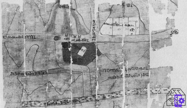
From Babylon, for example, comes a fragment of the map of the sacred city of Nippur: a clay tablet dating back to 1500 BC, where walls, city gates, various buildings and the Euphrates river are represented. Each single element of the map is described in cuneiform characters, so as to make it easier to understand. A solution also adopted by the Ancient Egyptians, who used to draw their own maps on papyri. The so-called "Papyrus of the gold mines“, In fact, it contains not only the design of the Berenice Pancrisia mining site in Nubia, but also indications in hieratic referring to gold and silver mines, miners' houses, wells, roads and even the Temple of Amun. A full-fledged map, which officially marks the origin of cartography.
The sphericity of the Earth changes everything
The history of cartography is inextricably linked to man and his knowledge of the Earth. Not surprisingly, the ancient populations used to represent in the maps what they knew - or had had the opportunity to see -. In this sense, the Greeks played a very important role in the evolution of cartographic representations. Around 541 BC, Anaximander of Miletus released one of the earliest maps of the Earth. The map is quite interesting: apparently, the scholar was convinced that our planet had the shape of a cylinder, on the upper surface of which the inhabited part must have been, probably in the shape of a disc.
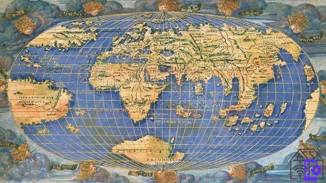
A rather abstruse belief, which was overturned a few centuries later by Aristotle. The confirmation that the Earth was spherical came from the new map of Dicearco da Messina, which introduced the indications of meridians and parallels to give an idea of the shape of the planet. From this moment on it was a succession of cartographic representations of all kinds, all aimed at representing the then known world. One of the major works is attributed to Claudius Ptolemy, author of the "Geography". It is a gigantic collection of maps of the Roman Empire, the Persian Empire and the surrounding areas, which cartography scholars used for centuries. At least until planispheres and atlases were introduced in 1500, a time when knowledge of the world was already very advanced.
The Ancient Romans, masters in the use of maps
Strange as it may seem to you, the use we make of maps today is mainly due to the Ancient Romans. These proved, in fact, to be expert topographers, skilled above all in drawing the maps of cities and territories. Among these it is impossible not to mention the "The beauty of the city of Rome“, A map of Rome engraved on marble slabs, which perfectly represents the shape of the city at the time of Septimius Severus. But that is not all. In fact, the creation of the itinerary book, ie maps designed to meet the needs of travelers by indicating itineraries and distances.
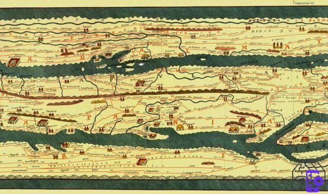
In this case, the forms of the places represented were not respected at all, because the important elements were clearly others. A perfect example of this is Table Peutingeriana, a cartographic representation of the Roman Empire, the Near East and India, to which are added information on the Ganges, Sri Lanka and China. Although the design may not be entirely accurate, the Tabula represents 200 kilometers of roads, over 500 cities and 3500 details including sanctuaries, lighthouses, rivers, forests and so on. In short, a real map. Like the ones we use today, or almost. After all, these maps appear to be the direct ancestors of Google Maps. Sure, it will take a few centuries, the advent of technology and much more, but the idea of a traveling map is undoubtedly the principle behind Maps.
Cartography in the information age and the arrival of Google Maps
One of the real great revolutions of cartography is undoubtedly represented by the introduction of aerial photography before, and of the remote sensing satellites then. The latter, in particular, have made it possible to computerize the cartographic representations, thanks also to the introduction of specific IT tools. We are in the early decades of the twentieth century when the GIS - Geographic Information System -, which allow you to digitize virtually any geographic data. An incredible evolution in the cartographic sector, which sees not only an enormous saving of paper for the representation of maps, but also an almost incredible accessibility.
As you can imagine, the biggest revolution in interactive maps is the advent of Google Maps, released by the tech giant in 2005 with the intent of providing users with a complete map e easily usable. Initially, the service only allows you to view maps of Japan, but in a short time the roads of the United States, Puerto Rico, Canada, the United Kingdom and some cities of Ireland were also added. In the following years Turin, Mars and many other areas of the Earth were added. And as if that were not enough, the colossus has then added the indications of rivers, subway stops, businesses, restaurants and much more.
In short, everything that can be used by those who have to move around the city on foot, by car, by public transport or by bicycle - the last real frontier of Google Maps -. Exactly like the old Roman maps, albeit improved in usability. After all, time passes and the interfaces for users too, but what doesn't really change is the intention with which tools of this type are produced. Don't you find it too?


![[Review] Samsung Powerbot VR7000: the robot vacuum cleaner from Star Wars](/images/posts/6bc44de38605b5c0fa12661febb1f8af-0.jpg)